

Preliminary Report on Plant Species and Vegetation Communities in the Yalburt Project Study Area
by Bochay I. Drum
18 August 2011

Introduction
This is a preliminary report on the communities of plants that we interacted with during our 2011 survey season. Vegetation patterns and the constituent species of vegetative communities help us understand specific site contexts and the overall landscape of our study region. Differing plant communities and species are correlated with variables in geology, soil type, water availability, drainage, disturbance, slope, and elevation. By looking at the interrelationships between these factors and the plants and plant communities, we are aided in our understanding of long-term interactions of human beings with all of the plants, waters and minerals.
Methods
In the 2010 and 2011 field seasons I observed the plants that grow in different areas, both by specific species and by type of plant community. For most survey units I made a non-comprehensive list of plants and grouped them according to different micro-environments I observed them growing in. Many plants and plant communities were left out from my lists. I have not yet done any complete survey of sections for plant diversity. The plants and plant communities that I noticed and recorded were those that were most directly related to archaeological site-contexts. I am certain that I missed many plants by not noticing or ignoring them. Many of the plants and ecosystems that we encountered in the Ilgin region were new to me and are still taking time for me to get to know and identify. Plant observations and identification from the 2010 and 2011 field seasons are also seasonally specific to mid-late summer.
During the field season I used the guide books Important Range Plants of Erzurum Province (UN FAO, 1988), The Rare Endemics of Turkey (Ekim, 2009), and especially Çayır ve Mera Bitkileri Kılavuzu (TC TKB 2005), and various internet resources, to identify plants. Most days during the field season I photographed plants at our survey units and then looked them up in the office later in the day. Descriptions in this report are meant to depict general plant and mineral communities that we observed, with their observed factors and some important constituent species. In future field seasons I intend to develop a more comprehensive knowledge and reporting of plant species and where they live in our survey area.

Figure 1. Mound with developed top (w/looting pits too), and a sequence of lower areas of recent disturbance dominated by different plants. The ring of tall grayish thistles directly below the top is Onopordium acanthium, then below that is a ring of yellow flowered Centaurea solstitialis, then Cirsium arvense, with its light green vegetation and pale purple flowers, and in the foreground, Achillea, Centaurea, Vicia, and grasses. SU120, Nodalar Höyük.
Plant Communities
The plant community types discussed here are divided by site type and general geomorphological location. This year we focused much of our survey work on mounds, so the primary and most extensive section in this report is on types of mound vegetation. The mounds we worked on are mostly located on plains or edges of plains, and a few were in foothill or slope areas, so in many cases the discussion of mound vegetation is also a discussion of lowland vegetation types in the Ilgin region. There is a brief discussion of upland and steppe vegetation communities after the section on mounds. Almost all survey areas are impacted by browsing and grazing herds of goats, sheep, and cattle.
In the discussions below, the term 'dominance' is a qualitative judgment that usually refers to what plant population looks like it has the most above ground biomass in the area, by species.
Mound Vegetation Communities
Mounds have a characteristic gray powdery soil that is generally compacted, yet fine and dusty when broken apart. In addition to mud-brick, mounds contain stones, layers of ash, charcoal, plaster, human and animal waste, bones, clay remains of other constitutions than the brick, and even ancient concentrations of organic matter (food remains). I am interested to see if specific plant species prefer to live in this kind of environment, and the relationships between soil type, land use and vegetative cover.
The majority of mound survey units we visited were situated in low plains where the bottom 2-6 meters of a mound can be buried under many meters of alluvial fill. The mounds are shrunken by erosion and tillage. The powdery gray soil of ancient mud-bricks slumps and mixes at its edges with the red and yellow floodplain soils. The mounds are much bigger than they appear at the surface. Their bulk lurks below the more recent soils, as little as two meters and as much as six meters down. There is some long term mixing between the soils on the edges.

Figure 2. Developed mound community with grazing pressure; grasses and Peganum harmala. The rose bush to the left is growing in an excavation pit. SU 101, Yalburt Yaylası.
Mound Vegetation Types
Developed mound communities
This designation is for mound areas that have plant communities that have undergone a period of development with a relatively low level of disturbance. Based on my limited fieldwork, I do not know the general time period necessary for such a community to develop.
This plant community is most often found at the top and upper slopes of the modern visible mound. This community type is seen in other low disturbance areas with a few meters or more of the gray cultural soil, such as the interior area of the Kale Tepesi (SU 104), and on long, low mounds such as Kulluk Hoyuk (SU 134). As stated before, the overall depth of the cultural soil is most likely much deeper than is apparent at the surface. Grazing and browsing by sheep, cattle and goats occurs at most if not all of our survey units, and this kind of ‘developed’ mound community is probably very strongly shaped these browsers and grazers. This kind of plant community is usually very closely contiguous to disturbed areas or areas under agricultural production.
The developed mound vegetation community is dominated by short to medium grasses, especially Hordeums (especially H. spontaneum), and varieties of Brome grasses that form thick mats, mixed with stands of intermittent individual herbaceous perennials. By the middle of july, 2011, at several mounds we visited, there were patches of grass that had fallen over sideways and formed horizontal mats of golden-brown straw up to 30-40 cm thick. The seeds of Hordeum spontaneum are fond of socks and shoelaces and gleefully travel along on them.
Herbaceous perrenials common to and/or definitive of this community type include Peganum harmala, and another plant that resembles a green Artemisia with a large taproot. These are perennial plants with deep taproots, and I believe them to be long-lived and persistent if relatively undisturbed. Many developed mound communities are distinctly marked by their extensive cover of Peganum harmala, particularly in the northern parts of our study region (ie north of the Ilgin plain). This includes Kulluk Hoyuk (SU134), Kale Tepes (SU 104), the Ottoman village of Kalekoy (SU 135), the höyuk at Yalburt (SU 101), Göktepe Hoyuk (SU 115) etc. Peganum harmala is also common in areas disturbed by humans that are not necessarily mounds. But even in harmala rich areas that are near obvious modern disturbances, generally a potsherd or two can be found. Mounds in the Ilgin plain do not generally have the dense, extensive harmala cover of the northern survey units. Some places have a few intermittent plants, often in developed mound communities or in more recently disturbed areas. At Nodalar Hoyuk (SU120), which is located near the southern edge of the Ilgin plain, I did not observe any P. harmala.
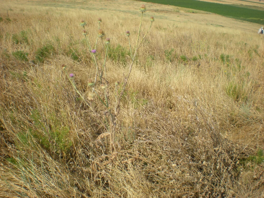
Fig. 3: Developed mound with Hordeum and other grasses and intermittent Peganum harmala. Looters pit in foreground with characteristic Cardus pycnocephalus, and a large Onopordum acanthium. SU116 Çayır Höyük.

Fig. 4: Mound with irrigated sugar beet fields in foreground (Note black plastic irrigation pipe), wheat field on right shoulder, and disturbance regrowth on center and left shoulder. in beet field. SU120 Nodalar Höyük.
Factors at work in developed mound ecosystems are high sun exposure, low water availability and usually a low elevation. Mounds generally have slopes, but the range of relief is relatively drastic, with some mounds being relatively low and flat (such as SU134 Kulluk Hoyuk) and some deliver a tall and steep aspect to the surface (such as SU 141 Gumuslu Hoyuk). Many slopes and edges of the visible bulk of mounds are cut by machinery (usually related to farming) and engender transitions in plant communities. Individual developed mound communities are similar, despite differences in the surrounding environment. I compare Yalburt Hoyuk (SU 102) to Kulluk Hoyuk (SU 134): The former is at a relatively high elevation, and exposed on a south-facing arid outcrop. The latter is at low elevation in a river valley, surrounded by trees and irrigated agricultural fields, yet they are both covered in Peganum harmala and grasses. The species of other scattered herbaceous plants at each site are different. Yalburt Hoyuk has the mullein that is common across the steppe, slope, and yayla communities, and Kulluk Hoyuk has common agricultural weeds such as chenopodaciae and convolvulaceae. I think that it is possible that there are particular effects of the mound soil, so rich with cultural remains, which are an important constituent to the development of the late-stage mound ecosystems.
1a. Trenches in developed 'late-stage' mound ecosystems
In several cases I observed very particular plants in trenches and pits dug into mounds in areas that were otherwise dominated by the grasses and perennial herbs typical of a developed mound community We did observe pits and trenches in developed mound communities that had vegetation identical to the surrounding area, and from this I inferred that pits with distinctive and different plants are more recent disturbances and those with vegetation similar or identical to the developed mound community are older. Two plant species that stood out to me in recently (I am guessing the dates as at least one, and up to several, years old) excavated pits and trenches are cleavers (Gallium aparine) and a thin thistle of some kind, that I am relatively sure is Cardus pycnocephalus, but could perhaps be Cirsium arvense. These plants in the excavation trenches and pits were dried up and brown in the July–August field season. Hawthorne and rose are also opportunistic growers in trenches dug into mounds.
2. Agricultural fields.
Every mound that we studied was at least partially used for modern agriculture. In some places only the edges of the visible mound were ploughed in. In other cases, part of the visible mound is used for agriculture, and at other locations almost the entire surface of the mound is being used as agricultural fields. Oren Cesmesi (SU 106) is a stunning example of a relatively tall mound that is almost completely under agricultural production. This involves continual disturbance and mixing of surface soil, and presumably hastens erosion. Most mounds have fields cut into their exposed bases. In some cases, entire low areas of above surface level mound have been scraped flat (see the case of Boz Hoyuk (SU 117) Locus 5 below). Agricultural plant communities are anthropogenic in their cycles and development. Based on comparisons of specific fields between our 2010 and 2011 field seasons we observed that most fields are rotated in terms of the crop planted each year. There is some evidence for be periodic fallowing of fields as well, such as the northern loci of Oren Cesmesi (SU106). Within a single agricultural season the vegetative cover is controlled in the following cycle; plowing, planting, harvest, and then sometimes burning and fertilization. Herds are often grazed through fields after the harvest is completed.
The most common crop is wheat, which is harvested in mid-july, leaving rows of stubble and chaff that provide some visibility for pottery pickup. The second most common crop is sugar beets, which require intensive irrigation, usually by sections of interlocking plastic pipes with sprinkler heads at the junctures. Water is pumped from irrigation canals or wells, by two-cylinder motorized pumps, or by electrical pumps hooked up to the power grid (there is an extensive spread of power lines for this purpose on the north Atlanti plain). The beets are very starkly green in the landscape, and actively transpire, which greatly increases the local air humidity, although the dispersal rate of the humidity at sites located in the open plain is also high.
Additional crops include maize, alfalfa, chickpeas, safflower, poppies, and sunflowers (often as borders for sugar beet fields, as at Nodalar Hoyuk (SU 120)). Sylvaculture is prevalent yet sporadic; trees are denser in low-lying areas close to water, and grow along and in irrigation ditches and canals. Medium and large commercial orchards are rare. Willows and poplars are very common, and apples, plums and apricots are quite common as well. There are occasional walnut trees, such as the grove at the northwest edge of Saracik Baglari (SU 129).
Agricultural plant communities also include specific sets of weeds that grow with the crops and/or grow very quickly in the torn bare soil of the freshly ploughed fields. Common plants in ploughed fields are Bindweed (Convulvus sp.), Lamb's Quarters/Goosefoot (Chenopodaciea), Acroptilon repens and Malva neglecta.
In one case, a visible difference in the weeds growing in a ploughed field corresponded with a visible transition from one soil type to another. At SU 117, Boz Hoyuk, the field at the SE corner of the visible mound (Locus 5) was part of the mound slope that got leveled to make a flat field. Cultural soils from this are present in a berm to the north, and most of the field is an exposed lower level of the mound (mixed with surface material as well). However, in the SE corner of the field there is a visible transition from the gray cultural soil to a pinker and yellower alluvial soil. This transition is like a vertical snapshot of the buried mound slope where it meets the material that is silted up against it. In addition to this visible transition in the soil, there is also a readily apparent change in the species of weeds across the soil transition. On the gray cultural soil, Acroptilons repens is the tallest and densest stand of plants. Immediately next to them, on the more colorful alluvial soil, Cirsium arvense fulfills the same role. It is possible that there are other reasons than this soil difference for this stark contrast in plant species, and hopefully we can clarify this by making more observations and learning about different soils and plants and their relationships.
It could be useful to ask farmers as to why they have mounds in agricultural production or not. My guess is that there are several factors that dictate these choices; mounds that are close to settlements and/or areas of high cultural activity are more likely to be in production, whereas mounds that are out in the agricultural hinterland are more likely to have their central high part disused for cultivation. The density of stones near the surface also probably has a lot to do with it as well. It would be interesting to explore the relationships between mound location, mound dates and relative stone content in relation to modern land use. The amount of work invested in stone removal could be a very unpredictable but interesting variable.

Fig. 5: Mound almost entirely under agricultural production, after wheat harvest; herd visible on mound. SU106 Ören Çeşmesi.

Fig. 6: Mound under wheat production and surrounded by sugar beet and wheat fields. Some sporadic fruit and walnut trees are growing to the left of the mound. SU129, Saraycık Bağları.
3. Vegetative re-growth in disturbed areas
This vegetation type is common all over, and present to some degree on or around all the mounds that we surveyed in the 2011 season. Some mounds, like Gümüşlü Höyük (SU 141), have their entire above surface bodies covered in this kind of vegetation. The lower sides and bottoms of visible mounds usually have some swaths or rings of this type of community. It is typical of road cuts, field boundaries, and really any area that has undergone relatively recent (less than 5 years?) soil disturbance. The typical species of this vegetation type are fast growing, thorny annuals and biennials. The most common and pervasive are probably Centaurea solstitialis and Onopordium acanthium, also Lactuca serriola. Other plant species and genera that I associate with this kind of community are Alhagi pseudalhagi, Achillea, Arctium, Daucus, Delphinium, Anthemis, Vicia, and Cichorium. Longer lived trees and shrubs, primarily Rosa and Crataegus, are also opportunistic to disturbed areas. There is a fair degree of variation in subsidiary plant species based on water availability.
On the mounds that have this kind of thorny dense vegetation dominated by Centaurea or Onopordium at their tops (Gümüşlü Höyük (SU141) and Mahmuthisar Höyük (SU 118), respectively), I suggest that there has been some relatively recent disturbance of the mound surface. In the case of Gümüşlü Höyük, it is possible that the entire mound was put under plow some time in the last 10 years, as the vegetation there is very similar to the lower slopes of other mounds that were probably plowed relatively recently. I don't know why the top of the mound at Mahmuthisar turned to a dense stand of tall Onopordium instead of a mixed stand of intermediate height shrubs.

Fig. 7: Soil transition from gray mound soil to yellower alluvium at SU117 Boz Höyük. The taller plants growing in the dirt are different in the two soil types. The visible mound area to the left background is a mix of developed mound ecosystem and disturbed. A miniature ecotone.

Fig. 8: Disturbed area with thick stand of Centaurea solstitialis. Below the tekke at SU124, Dediğin Dede.

Fig. 9: Disturbed mound top covered in dense thicket of Onopordium acanthium. SU118 Mahmuthisar.

Fig. 10: Heavily grazed mound top; bare soil, grasses, Peganum harmala, Artemisia. SU140, İmircik Höyük.
4. Heavily grazed mound
I don't have a fully formed concept of this plant ecosystem yet, but am thinking particularly of Imircik Tepe (SU 140), which is highly denuded, with patches of bare soil and a scraggly community of Peganum harmala, grasses, and Artemisia. More work should be done on this type of vegetation community.
Upland Steppe Vegetation
Classifications in this section are highly tentative. There is a need for further fieldwork, and further study in the literature before concise classifications and exposition can be delivered. Here are some preliminary observations:
The most definitive upland genera that I observed in our survey region were Artemisia, Eryngium, Verbascum, Astragalus, Euphorbium. Each of these seems to be most prolific under different conditions, but in general this kind of plant community thrives in what could be termed as marginal conditions; steep slopes with thin, rocky soil and very little water.
1. Artemisia slope
This vegetation community is common on slopes such as that at Kale Tepesi (SU 104), between the spring and front wall. As the name implies, this plant community is dominated by Artemisia species. Other common genera include Eryngium, Phlomis, various grasses, and sometimes P. harmala. One variation of this Artemisia steppe includes a less dense population of Artemisia growing with Acantholimon.
2. Mid-elevation karstic upland steppe
The higher steppe up around Sangir Magaza does not have so much Artemisia. Instead it is dominated by small grasses, Eryngium and Verbascum. Acantholimon and Euphorbium are also common.
3. High elevation karstic upland steppe
Higher up and further into the karstic mountains north of Lake Cavuscu, the steppe in the low lying areas to the east of Dokuz Hoyuk (SU 146) is dominated by Eryngium, growing in a fair amount of red soil. The vegetation there changes on the slopes and rocky ridges; there are more grasses and Verbascum is the dominant herbaceous plant. At other upland locations there are only dried grasses visible during our mid-late summer field season.

Fig. 11: Dense Artemisia steppe on Kale Tepesi, SU104. Eryngium in foreground, Phlomis (tan) and Artemisia (blue-gray-green) in background.

Fig. 12: Higher elevation steppe; dominated by sparse grasses and Verbascum. Lone hawthorn (Crataegus) tree in background. SU 103: Şangır Mağaza.

Fig. 13: Karstic upland valley with Eryngium, Centaurea, perhaps Carthamus, and some dry grasses. Immediately east of SU146 Dokuz Höyük.
Future Work
1. Comprehensive identification of plants and plant lists for communities. Work especially needs to be done on grasses and small herbaceous ground covers. Specific problem plants that are very common but have eluded my identification are:
Dense, very spiny, tiny purple-flowered, probably centaurea that grows in disturbed areas. Large stands this season at Cayir Hoyuk, especially in dump-truck sized dump area.
Small herb that resembles thyme and the like; tiny little leaves close to stalks that radiate from a large tap root. Very common in mound sections.
Plant with lots of little hairs on it, maybe Alkanna?
2. Ethnobotanical work: An ideal foray would be a 'plant walk' with a knowledgeable local informant who could help us with plant identification and provide any additional information and lore about them.
3. Additional plant communities need clarification:
Pasture; including heavily grazed and trampled mounds, differentiation and identification of steppe types
Wetland (stream, lake, marsh) communities
4. Intensive quantitative survey of plants and plant communities. Potential methods include: Count all of the plants in a square meter that is representative of a plant community. Another method is to make a 50 m (or other length) transect and count all the plants that the line touches.
5. Develop timelines for development of different communities/understanding of details of succession patterns. How long do communities of plants that thrive in disturbed areas persist?How long does it take to develop a later stage mound community? What are the relationships between land uses of varying intensity (grazing and agriculture) and regrowth?
6. Fieldwork in other months of the year. The 2010 and 2011 field seasons both occurred during the months of July and August, and I believe that my plant observations from those field seasons are biased towards flowering biennials and perennials. It would also be useful to look at the plant communities (or similar ones elsewhere) in a season other than mid-late summer. Many plants are dried up and difficult to identify during our field season. There may be significant populations of flowering annuals and smaller perennials that would be more visible in the springtime, after the last frost and after some rain.
Bibliography
Ekim, Tuna; 2009. The Rare Endemics of Turkey. İstanbul : Türkiye İş Bankası Kültür Yayınları.
Ertuğ, Füsun; 2000. “An Ethnobotanical Study in Central Anatolia (Turkey))” Economic Botany 54, 2:155-182
Rhind, Peter Martin; 2010. “Plant Formations in the Central Anatolian Bio Province. Terrestrial Biozones" (web resource)
Tatli, A.; 1988. Important Range Plants of Erzurum Province. Aralik, Turkey: UN FAO.
TC TKB; 2005. Çayır ve Mera Bitkileri Kılavuzu.
United Nations FAO; 1986. “Sheep and goats in Turkey.” FAO Corporate Document Repository.